My only regret in writing up this trip is due to the time that it has taken in getting down to work on the notes. The details, however, are still clear to me — and I hope they will be to you.
Both Mr. Jackson and I had thought of the possibilities of such an expedition long before we actually discussed them together. The Mississippi, being the longest and most navigable river in the country, has made it the subject of many interesting stories — some true, others false, as we later discovered. We knew that a trip down its waters would take us through a wide range of interesting and out-of-the-way territory. This, along with the novelty of such a trip, intrigued the both of us.
And so it was not surprising that one evening, after lightly scanning our homework, our conversation drifted into more interesting fields and the idea of a river voyage was broached. The dream materialized when Howie mentioned his possession of a kayak — and that it could possibly be fitted for such a journey. I promptly jumped at the chance, we shook hands on it, and decided then and there to pool our resources for the trip.
A slim sixteen-foot craft
Little time remained. We were nearing the end of the school year, and as we were both struggling through school on a shoestring, the trip had to be economical. We took a mental survey of the equipment available and found that the initial expenses would be at a minimum. At our first opportunity we left school for a weekend to gather what materiel we had, and to buy the few additions necessary.
While at home I joined Howie in La Grange, and we took a look at the craft that was supposed to take us to New Orleans.
It — the kayak — was indeed a beautiful job of workmanship. It was a slim sixteen-foot craft, about three and a half feet at the widest point, built to ride low in the water. The shape of it was needle-like, tapering to a sharp point at bow and stern, not turning up at the ends as does a canoe. The construction was light but sturdy, composed of aluminum and hardwood ribbing covered by durable airplane canvas stretched tightly over the frame. The total weight of the craft was forty-five pounds.
This type of craft, patterned after the durable kayak of Eskimo origin, is speedy in water chiefly because of its lightness and its lack of resistance to the water. As in the Eskimo variety, the front and rear topsides were also covered by doped canvas which also ringed the cockpit. The flooring of the cockpit was plywood, and a combination backrest and carrying bar was constructed from gunwhale to gunwhale in the center.
This would be, to our knowledge, the first time that such a vessel would make the trip down the Mississippi. In spite of its streamlined appearance I must admit that I did not share Jackson's pride and confidence in his kayak. I could visualize such a conveyance scooting over the placid waters of the Garfield Park lagoon — but what would it do on the Mississippi? It certainly could not withstand contact with even a small snag or submerged log, and inexperienced as we were, we knew that the Mississippi was famous for its annual crop of deadwood. Jackson, preparing for the inevitable, added to our stores a supply of canvas, paint, and dope. Repairing a rent kayak resembles tire patching, except that a good innertube has a much longer life expectancy.
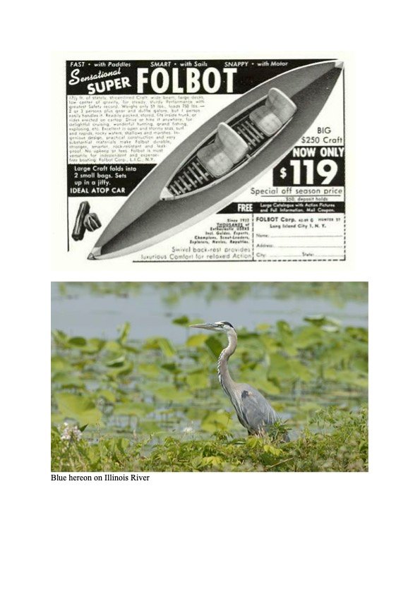
A folding kayak of the era — and the great blue heron, "hermit of the river," that would be their first sign of life.
The carrying capacity was light — 450 pounds — meaning that only essential articles could go. Consequently the list of supplies was short:
2 army field packs (carrying work clothes, shaving gear) · 2 sleeping bags · 2 canteens, cups, and covers · 2 army messkits · 1 Delta flashlight · 2 four-and-a-half-foot canoe paddles (very essential) · 1 sheath knife · 1 brush knife · 1 poncho · 1 hatchet · 3 bottles of mosquito ointment.
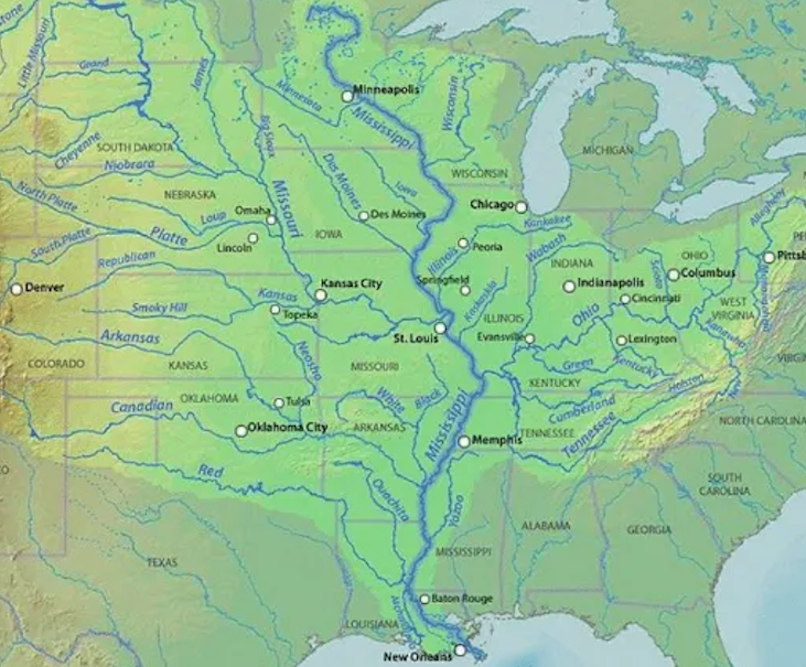
River navigation charts were also needed, both of the Illinois River and of the upper and lower Mississippi. The charts of the Illinois and Upper Mississippi were procured at the office of the District Engineer in the Merchandise Mart, Chicago. Howie had to write to Vicksburg for the charts to the lower river from Cairo, Illinois to New Orleans.
The maps, when pieced together, represented a lot of river miles — all of them unfamiliar. Canoe paddles seemed suddenly to be a frail means of propulsion.
We then determined when and where the voyage would begin. The starting point would be near the Route 9 highway bridge crossing the Illinois River just south of Peoria, and the date August 1st. The waters are at a low stage during the months of August and September, and we wanted the kayak — as well as ourselves — to have all the chances we could provide.
Into the first mile of river
Everything seemed to be settled. From then on we waited. School dragged by, and the first part of summer vacation followed as slowly. Due to a date with the 5th Army which unfortunately had to be kept, I held up the journey for three days.
Finally, on the morning of the 4th, we lashed the kayak and stores onto the family vehicle and headed for Peoria, arriving at the highway bridge at 9:30 A.M. Loading our few camping supplies, some canned foods, and a box of sandwiches and candy that mother had thoughtfully prepared, took little time. Each small space had to be utilized — the packs and other equipment being stored in the front and rear spaces. We used the sleeping bags as seating pads, and for backrests used the two kapok life cushions that Jackson had also provided.
When the craft had been loaded and placed in the water it looked beautiful — neat and shining under its new coat of green paint. But, would there be any room for us?
Jackson gave me the dubious honor of getting aboard first. I clumsily boarded, gripping the gunwhales and swaying like a tightrope walker on his first act, while Howie, up to his knees in Illinois river mud, attempted to steady the kayak. Finally I dropped into position in the front, and Howie — much more experienced in such maneuvers than I — climbed in at the responsible position of steersman. The current wasted no time in sweeping us under the highway bridge and into our first mile of river.
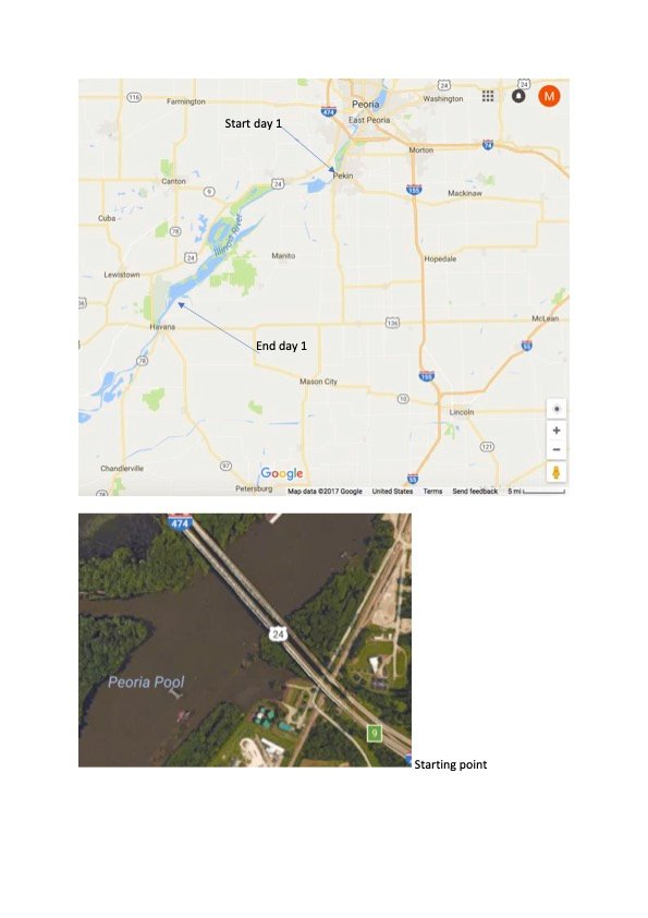
The first day's run — launching south of Peoria and ending downriver near Havana.
We had an exasperating time of it at first, trying to adjust into comfortable positions — a seemingly impossible task — and trying to keep the kayak headed in the right direction. Howie must have been driven to the brink of madness. I was a greenhorn and did not know how difficult it was to synchronize paddle strokes with those of the steersman. The kayak, due to my sincere but inept paddling, kept veering from one side to the other in spite of Howie's efforts. It is to his credit that he remained patient, as my blundering would have distracted a saint.
If there is an easier craft to capsize than a kayak, I would like the visible proof. Just as in canoeing, a sudden leaning to either side is liable to invite disaster. In this respect our capacity load probably helped us, for try as I would, movement of my lower body was balked by baggage. The water slid by. Its proximity, and the realization that half my weight was below water level, was certainly no morale builder. The water line of the kayak amidships was six inches from the gunwhales — a discouragingly low margin of safety.
But we were afloat at least, and on our way. Jackson, forewarned of my ineptitude, was prepared for a long day and beaucoup short mileage.
In many respects, our first day out was one of the most interesting — due largely perhaps to the novelty of river travel. The Illinois river, in spite of its contamination by man, still has some beautiful water. It is an old river, its whole meandering length dotted with large low islands all heavily wooded. The weather was on its good behavior, and the sky, which had been cloudy at first, cleared. A low breeze kept the summer heat away.
The Illinois still has its share of bird life. The great blue herons — hermits of the river — were our first sign of life, and provided comedy skits for us at every turn of the river. This is one bird that just can't seem to stand humans. Each one he sees shocks him as much as the last. In spite of the silent approach of the kayak we never could get too close to them. From a distance we would observe one pacing stiltedly over the mud banks, seemingly intent on his search for food. Then suddenly his long neck would straighten up, he would stop as if listening, gawk at us, and finally flounder his way into the air, gargling epithets.
Many poets have praised the beauty of a bird's flight. These men apparently weren't acquainted with the blue heron.
We also saw flocks of egrets on our first day out, which came as a surprise to us both. We had supposed that such birds were very rare and that they were strictly southern in habitat. They are graceful, seemingly effortless in flight, and their pure white plumage emphasized their clean lines. My only regret is my inexperience in bird lore, and the sight of many strange species was frustrating.
The condition of the water gave visible proof that the river had been badly treated for a long time. Though it was once one of the best fishing rivers in the state, water travel and careless disposal of factory wastes has taken a heavy toll. This pollution, combined with good Illinois farmland, keeps the Illinois river cloudy the year round. The bass fishing for which this river was once famous is now non-existent. The only species of fish that seemed to be in evidence were catfish, carp, and gar — which can live and even thrive in such water. All of these fish are enemies of the real game fish.
Aside from occasional fishermen and one Coastie launch that passed us on its daily patrol, we had the river to ourselves — which is fortunate, as any spectators would have died laughing at us. Heavily wooded banks stretched out for miles without a break in their greenery. We kept to a leisurely pace, taking a long lunch period and after that frequent rest periods during which we just drifted, letting the current do our work for us. Our muscles, unused to the task set them, protested vigorously, and we thought of our first night out with misgivings.
Each navigable river in the U.S. has its markers, or "lights" — usually tall, wooden tripod-like structures equipped with lamps (night navigation aids) and a mileage marker plaque. The marker board shows the number of miles to the river's end. The lights were of great help to us on the trip. They made it much easier for us to associate the map with the actual terrain, and kept us oriented along the right channel. Also a great help were the frequent and very necessary marker buoys, which show the sailing line. This is good thing to know when sandbars and mudflats are common occurrences.
Looking over the charts we noticed that we had started our trip in the vicinity of mile 153. This meant that we had 150 miles to go till we would arrive in Grafton, Illinois, and hit the real Mississippi. When we planned the trip — dreamers that we were — we had thought up a definite schedule. Any type of schedule for river travel, we found, is almost impossible if you are travelling by sheer paddle power. Another misconception was the idea that half the trip would be just easy drifting. But the current was too unpredictable, and just staying with it sometimes turned out to be a full-time job.
It was fortunate that we had the opportunity to break ourselves in gradually by starting on the Illinois river. By the time we got to Grafton we were working harmoniously and had a pretty good idea of what the kayak could and couldn't do.
The afternoon of the first day was real torture. Neither of us wanted to suggest rest periods, but I know that the word loomed large on the horizon of my mind that day. My whole body seemed to be one large sore throbbing pulse, and I have a feeling that Jackson was in the same way. We had planned to make our first town stop at Liverpool. There we would buy some provisions and refill our canteens. At last the thriving metropolis of Liverpool loomed on the horizon, a boon to our tired eyes. I suppose that the population of Liverpool is about 90 souls, and the downtown section is made up of a very few well-worn stores. But to us, it was Heaven.
At one time when commercial fishing was good, Liverpool had a reason for existing — but now only a couple of fishing shacks remain. These, and a few barges moored nearby, were the only evidence of industry at the time we stopped. We made for town immediately and had a few assorted meat sandwiches, as well as a quart of milk apiece, in the town's one and only sandwich house. Refreshed to some extent we decided to get in a few more river miles before nightfall, so our stop in Liverpool was shorter than expected. We bought a few more canned goods and a dozen oranges and then headed back to our mooring. It was about 6:30 in the evening when we pulled away downstream.
Evening travel on the river is the best. The winds die down, and all other sound fades. The river becomes a magic land as all shades of trees and water are intensified by the setting sun. Then too, it is cool — and for some unknown reason easier to make good time. Perhaps you could call it the spell of the evening. I don't know.
We had hoped to make it to the next town, Havana, Illinois, by nightfall. But time and tides were against us, and soon it began to be difficult steering clear of snags because of darkness. Finally we had to pull up and face the mud. The Illinois is far from a sandy river. Camping along its banks can be extremely annoying because of this. The spot we picked was a little bit better than average for an Illinois river campsite. For some reason there was a sizeable mound of old shells of all kinds, which we hoped would serve as sort of an insulator between us and the beautiful black mud of Illinois. After tying the kayak down for the night, we built a small fire from the plentiful supply of driftwood nearby, and spread out our sleeping bags on the shells. Lumpy? You're darn tootin' — but we were too tired to know the difference that night. That night also gave us our first chance to use some of that army surplus mosquito ointment. The mosquitoes loved it... and again we were too tired to care... which accounted for our lumpy appearance on the morrow.
Havana, and onward to Beardstown
The first day of any trip is always a memorable one. As you go from one day to the next, events seem to blend together till only the outstanding ones remain.
The fifth day of August blossomed out gloriously. In spite of our aching tissues we were up with the sun, packed, and launched in no time. Surprisingly enough, our arms didn't give us too much trouble on the second day. Perhaps they were numb — but it was a relief after the day before.
We had hopes of good mileage, as usual. The first day hadn't been too pure as far as mileage went. The log notes indicate 30.5 as our first rate. We picked Beardstown as our target for that night, which meant another 35.6 river miles out of the way. Breakfast could wait, we decided, until we pulled into Havana — which was only a few miles downstream.
We were there by seven o'clock and wolfing down flapjacks in a town café by eight. The only time references that I can give are borrowed from someone else. We, fortunately, did not possess a watch, or timepiece of any kind. We got up by the sun and retired with that same timeless and venerable object.
Havana is a pleasant medium-sized river town — clean, and quiet. We spent a short time shopping, in which I picked up a sweat shirt that was lurid enough to be radioactive, walked along some of the shady streets, and then headed back to our craft.
The river became noticeably wider on the second day. Otherwise the landscape was about the same. The calm river, the green band of trees along the shore, and the omnipresent population of waterfowl. Signs of habitation were rare, which struck us as rather strange, as we were passing through country that is supposed to be intensively farmed. The answer to the puzzle came with a more careful scrutiny of the maps. Between the levees and the river is swamp or woodland, lakes — nothing more. The land would be impractical for building or farming, as it is inundated without fail each year. Strangely enough, the banks of the rivers themselves are higher in elevation than the land behind them. This occurrence, according to Jackson, is called a natural levee — or the piling up of layers of sediment during flood season.
The current was also better on the second day, and we felt that now and then we could do a little drifting and watch the buoys go by. It was a very slow day as far as river traffic was concerned. Again we had the river to ourselves.
We stopped for lunch near mile 108 at a place called Holmes Landing. At this point the current was a little swifter than usual, and we had to make a couple of runs at the landing before we hit it satisfactorily. You can't just ram a kayak up on the bank — the canvas rips too easily. You have to find a spot you know is free of any sharp projections such as snags or rocks. After a quick and clashing lunch of sardines and cold beans we headed off down the river again.
The afternoon was perfectly calm and the first real hot weather set in. We both changed into swimming trunks, feeling that it was better to burn and get it over with, rather than swelter in our clothes. Happily we had thought of bringing along a couple of baseball caps for protection from the glare. But it still felt sometimes as though we were at the focal point of a huge magnifying glass.
We were finally working smoothly together, which made paddling a lot less of a strain and gave us more mileage. The day wore by without any mishaps and it began to look as though we would make the destination we had planned on, which was Beardstown, Illinois. The welcome coolness of early evening and the stillness of the water made our last few miles to Beardstown a real pleasure, and consequently we were in pretty good frame of mind when we arrived.
We pulled the kayak up just above the Beardstown bridge in some willows and took off for the main part of town, where we busted our budget by purchasing a pair of tantalizing T-bone steaks plus all the trimmings. Then to make the festivities complete, we took in a show, through which we both slept intermittently. The show was called "The Big Clock," and was very good — but being closed up in a warm theatre after all the outdoor exercise was a little too much for us.
Beardstown was a typical midwest town with the usual town square loaded with benches, old cannon, and a statue or two. The most prominent river landmark is its sea wall, which was put up for flood control. We wasted no time in hitting the sack after the show. A slight drone in the air plus a few more tangible reminders of the class Insecta prompted us into putting on a good coat of ointment before retiring, and so the night passed fairly comfortably.
The first portage at La Grange
On the seventh day of August we ran into our first river boat. It was of the typical squatty tug that plays such a big part in pushing barge freight up and down the inland waterways. As the trip progressed, barge traffic became commonplace, and it became a routine matter to plow over their waves.
The boat screws plus the wake of the barges sometimes throws up a good swell. The only thing you can do when one goes by is to head as close to the bank as possible, giving the waves a chance to even out a little. Then when the crests are nearly upon you, turn the prow of the craft into them and hope for the best. The kayak stood the test admirably, being short enough to ride over the waves instead of through them. In fact, if you are going downstream and a river boat passes you going in the same direction, the waves help to carry you along.
We didn't see a single paddle wheeler on the Illinois — and if we had, the story might have been different. A large paddle wheeler going through a comparatively narrow stretch of river is like a portly gentleman falling into a bathtub. A lot of the water leaves the main channel and is deposited on the shore in the form of big breakers. Boatmen on the Illinois and Mississippi always tie their small boats down pretty securely when they beach them. Either that, or pull them far up on the shore. If your boat isn't moored well, and a paddlewheeler or big tug goes by, you might just as well kiss your belongings goodbye.
On this day we also made our first portage. We hit the La Grange dam and lock system sometime in the morning. There wasn't much activity there at the time, just a few fishermen on the south side of the dam, and the usual lock keeper. We pulled up on the west side of the river nearest the first locks and unloaded. It wasn't much of a portage, the distance around the dam and locks being in the neighborhood of 200 yards. We made it in two grunting trips. After dropping the kayak in south of the dam and reloading, we had a short talk with a couple of fishermen. When they had silently appraised our water vehicle and wormed our destination from us, we had the slight impression that they thought someone was crazy — namely us. But they were very pleasant conversationalists, as were most of the river men we met on our journey.
We made Meredosia, another small fishing town, our noon stop. There is still some commercial fishing done on the Illinois. Numerous carp and catfish are hooked or netted for market — probably Chicago. The fishermen on the docks at Meredosia were in the act of cleaning and packing some carp when we arrived. There is a knack to every trade. They had those carp beheaded, scaled, gilled, and gutted in less time than it takes to type these lines.
There was a little floating wooden cage attached to the barge that seemed at first glance to be empty. Closer scrutiny showed that it was filled with good sized snapping turtles. How they managed to catch so many remained a mystery. Probably these big fellows worked their way into the fish traps, were caught, and would be disposed of later at the fisherman's whim. There were a couple in there with the shell circumference of a good-sized dishpan. As we stood still for a while watching them, quite a few of the snappers surfaced, looking at us just as intently. They have peculiar dull-looking eyes, and horny jaws that give evidence for their well-earned name. Some of the older ones still had green river moss growing on their backs. This, and the natural muddy color of their bodies would make them practically impossible to see in their natural habitat. And after a good look at one, I don't think that I am overanxious to do so again.
The afternoon went by smoothly enough. The river was again noticeably wider, and the topography also began to change. The west bank became noticeably hilly, showing some very lovely terrain. Up until this day, the woods had been restricted to the swampier species such as willows, cottonwoods, and cutleaf maples — and other trees that are able to stand an annual root bath of flood water. Other kinds of trees were now visible on the new country, which was still rather heavily wooded. Oaks, hard maples, elms, and other species grew profusely on the slopes. There still seemed to be some pretty good timber in this area. Being out of the flatter, wetter country was a relief to us.
We travelled on until late in the evening, until we saw the lights of a small town which had a landing of a sort. When we pulled up to shore, we found that some other travellers had also picked this spot. A couple of coast guardsmen, apparently old salts of the inland waterways, greeted us. They were on leave as it turned out, and were just returning from a motorboat excursion to Starved Rock up on the Rock River. Their duty station was Alton, Illinois.
The name of the town turned out to be Florence; population probably about sixty people and certainly twice that number of canine residents. But it did have one store, which served sandwiches. We dined on hamburgers as I recall, and very good ones too — apparently Florence never heard of a meat shortage.
After supper we wended our way back through the woods to the campsite, where the coastguardsmen were having a coffee bull session before retiring for the night. We talked to them for some time. They were very interested in our trip, if skeptical, and gave us some pretty good clues as to what to expect farther on down the river. Who would know the river better than the men who have to patrol it the year round.
They told us that the going would be good until we passed the dam and locks at Alton, but after then to expect some tricky water. They warned us particularly of the water around the Chain of Rocks bridge, just below the junction of the Missouri with the Mississippi, and of the water along the Saint Louis waterfront. They were apparently concerned over the type of craft we had, and after listening to a few of their stories, so were we.
The coasties also warned us of the big river boats which would occur more and more frequently south of Alton. According to them, neither hell nor high water will make a river boat captain veer from his course. If you are in the way, that's just tough — you should know better.
A first mishap at Grafton
We again got off to an early start, although our destination for the day was Grafton, Illinois — only 21 miles distant. But what a 21 miles.
We met more river traffic on that day than we did on the entire Illinois. The river is happily much wider between Hardin and Grafton due to the nearness to its mouth and perhaps partly to the large dam at Alton. The wide river enabled us to hug the shore and keep away from the larger boats to some extent. The bluffs faded away shortly after we left Hardin and there were again lowlands on both sides of the river.
Just before noon we stopped off on Six Mile Island. A houseboat was perching on the north side of the island way above the water level. We had quite a talk with one of the occupants who apparently wasn't too concerned with the high and dry position of the houseboat. He calmly mentioned that they would be launched again with the spring floods, that the island was a fine site for camping, and that they were in no particular hurry to be waterborne again. Nobody hurries on the river, this was repeatedly proved to us.
The houseboatman suggested that we stop for lunch at Père Marquette State Park which wasn't more than a mile distant. He also suggested that we take a shortcut that would take us around the west side of the island. We followed his advice, for which we were later sorry. The side channel was stagnant, shallow, and snag-ridden, and when we finally emerged from it, the park lay directly across the river. In the meantime a good breeze had come up and we had to buck waves to get to the other side. Several motor launches were also in the vicinity, some of them pretty good sized, which added to our discomfiture. Motor launch skippers sometimes have the tendency to be sadistic. We were nearly swamped by a couple playful boats when we were mid-channel. But we made the park breakwater without capsizing, which seemed a minor miracle to us.
After tying up, we took a stroll around the park grounds and also took a look at the lodge — a truly beautiful piece of architecture. After seeing this lovely spot I would recommend it as a stop for anyone who passes through that area. It seems to be a fairly recent development and is maintained at maximum efficiency. Even a couple of crummy looking bums like us received courteous treatment there.
We sat around for a while letting our sandwich lunch settle, and when it did, we took off again downstream. The water between the park and Grafton was a turmoil of recreating Illinois citizens. We were continually turning into the waves created by passing launches, and for this reason were a lot later in arriving than we had planned.
We pulled up to a grating stop at the shores of Grafton. The grating noise was created by a couple of sharp rocks which put a couple of neat holes in the bottom of the kayak — our first mishap. We promptly pulled the kayak up on a rusty abandoned barge, and batting away the evening crop of mayflies and mosquitoes, did a hasty repair job.
Into the Mississippi
Up bright and early again. We had a short breakfast in town, and with the purchase of a few canned goods were ready to hit the road.
At last we were in the Mississippi, and received a royal reception. The river is very wide at this point because of the dam and lock system below. The wind had full play on this water, and whitecaps started to form. We were out in midchannel at the time. A few started to come over the sides, and by the time we struggled to the shore the water line of the kayak was appreciably higher. We and our belongings took a terrific soaking. This was our first experience with the changeable water of the river and we were pretty discouraged. This meant more delay while we drained our craft, and dried out our equipment. We put in at Chautauqua, a small resort colony on the east bank.
The wind showed no signs of dying down and for the rest of the day we hugged the shoreline. It is fortunate that the weather drove us in close. If it hadn't, we would have missed seeing one of the loveliest towns on the river — Elsah.
Elsah, and the locks at Alton
The east bank of the river from Grafton to Alton is lined with high bluff country and heavy timber on the slopes of the bluffs. Elsah is located in a sort of a draw that runs back into the wooded hills and is very hard to spot from the river. The only actual landmark is an old limestone building which is partially caved in (probably due to a landslide) and a few other old edifices which are almost concealed by the trees. We pulled up near to the bank and asked a couple of fishermen what chances we had of procuring refreshment nearby. He told us of a little sandwich shop uptown, so up the hill we went.
Many of the buildings of Elsah are made of native limestone quarried nearby and probably date way back to the early days. Actually the town is a combination artist colony and college town. Principia College, the only Christian Science college in the country, is nearby and supplies some of the few contacts with the outside world that Elsah has. After seeing the town and its quiet beauty I can see why people would hate to leave. And for an artist it would be paradise itself.
There are many lovely spots along the river that are never mentioned in the travel folders, and for the sake of the people who love seclusion this is just as well. We talked at length with the proprietress of the restaurant and learned that Christian Scientists from all over the world have come to Principia College and that the school is quite well known to the people of that faith. After wandering up and down the steep slopes of the town and studying some of the old buildings we reluctantly headed back to the river.
We picked Alton as our destination for that evening. The dam and locks there would be our last portage and we had hopes of finishing this before pitching camp. The rest of the day was just hard paddling, with the wind and waves against us most of the way. But the scenery along the bluff country is hard to beat anywhere, and the memory of that day is a lasting one. Many people have appreciated the natural beauty of this country enough to have built homes on the cliffs. Some are very striking, especially when seen from the river.
We reached the locks just before sunset. It was a longer portage than the first one, and by the time we were loaded up on the other side and ready to go again it was dusk. Just downriver from the dam and locks is the Alton Highway bridge. Rather than camp on the town side of the bridge where there were many fishermen, we decided to take no chances on losing our gear and head for the other side of the river. We crossed over, skimming past the bridge pilings to the other side, and laid out our sleeping bags on a good hard spit of dry sand. The current south of the dam is swift, and actually by the time we had pulled out of the river we were considerably down river from the bridge. But both Howie and I wanted to see what the town of Alton was like, which involved a good hike back up the river bank and across the highway bridge. We got into a slight brush with one of the bridge watchmen who told us that pedestrians were not supposed to cross, and that we should wait at his station until some softhearted driver would pick us up and take us the rest of the way. Our appearance was too much for the drivers that we saw, however, and finally we were allowed to walk the rest of the way.
Alton is a sizeable and gritty town, and after wandering the streets for a while we decided that we'd had enough. Rather than rub the watchman the wrong way again we procured a cab and got a lift back to the other side. Then back to camp and a good night's sleep.
Through the Chain of Rocks
This was the big day. Today we would hit the waters of the Missouri and pass under the Chain of Rocks bridge. Anticipating some hard paddling, we were off to an earlier start than usual, getting underway before sunrise. It was a quiet dawn for which we were thankful; the water was glassy and fairly fast.
We breakfasted in the industrial town of Wood River, a far from scenic town and not worth the long hike to get there. The whole stretch from Alton to St. Louis leaves much to be desired and made us wish that we had a good stout motor to whisk us through it. It is just one long succession of oil barges, smoky factories, and refineries. The west banks are flat and the water is covered with oil slicks. Very unpleasant paddling.
After the Missouri came in we didn't have much of a chance to study the landscape. There is a sharp line of demarkation between the waters of the Missouri and those of the Mississippi. At the point where the big muddy rolls in, the water turns to a dark brown about the color and consistency of very potent coffee. And the current really begins to pick up — even without the change in color of the water we would have been able to tell the exact meeting place of the two big rivers.
The markers on the banks really began to go by, and for a while we just stopped paddling to see what the current could do. We relaxed almost too much. The Chain of Rocks Hwy Bridge was almost over us before we realized it. We had been advised by the Coastguardsmen that the water under the bridge was very tricky, and to pass by it close to the bank under the first section. We just had time to pull over by fighting the current with all we had. Then we backwatered near the shore for awhile, trying to determine the best way to get through.
Their advice seemed to be faulty. The water near the west bank was nearly as swift as the middle course — fast enough to bang some of the looser pilings against each other which created a very noisy and discouraging sound. There was also a lot of deadwood snags and old pilings at this point that could break our kayak up in a hurry if luck went against us. We finally decided to risk the middle channel in spite of advice to the contrary. So we pulled back up a couple hundred yards along the shore and headed out to the middle. The real current picked us up there and almost threw us out of control. We were so busy trying to keep from swamping that we were under the bridge and away before we realized it.
I will remember the sound of the water around that bridge for a long time... there is terrific power in the river... its sheer volume is impressive.
All in all it was nice to know that the Chain of Rocks, one of our biggest obstacles, was behind us.
We stopped to regain our breath on a big flat sandbar just north of St. Louis, and as usual, our presence was resented by a big colony of herons that was living there at the time. The skyline of St. Louis could be seen from our vantage point (Mosenthien Island, mile 186). Rather than buck the whirls and eddys of the main channel all the way into town, we took in a few miles of smooth water between the island and the east bank. We were just in time to see some poachers shooting at some egrets. By the time we had beached they were gone — leaving a couple of sad reminders behind them. We found two birds that were just left to rot on the beach. What a brutal and pointless way to have sport.
After a while we broke out into the main river and struck out for St. Louis on the other side. As usual the wind had it timed perfectly, and a good breeze from downriver hit us about midchannel. The waves created by this wind were very strange — all conical and all going in different directions, so that it was hard for Howie to judge the manner of hitting them. The current was still going lickety split which didn't help matters out, and again we shipped some water. River boats went by pell mell without much regard for the small fry, and it was with no small relief that we finally pulled up at the St. Louis Boat Club. We were well received by a couple of Chris Craft skippers who gave us permission to sack out on their dock for the night.
After cleaning up and putting on some shabby but presentable clothes we headed uptown for the evening. Howie took off for points unknown and I spent the evening just strolling around looking at the sights. Saw a show, "Easter Parade," which was about the height of my entertainment for the evening, and retired back to the wharves. The dock may have been hard but I was asleep before I hit first bounce, returning to consciousness about seven o'clock the next morning. Just in time, in fact, to see Jackson loping down to the docks. He had decided to splurge and had spent the night in a hotel.
A botanist's eye on limestone bluffs
Needless to say it was a pleasure to see those Crystal City shores fade away up river. It had seemed for a while that our luck was turning away from us in bunches. As yet the weather had remained ideal. There was no rain and little wind. Days remained hot and nights cool. Many times we praised the Lord for those cool night breezes that play along the shores at night.
The country south of Crystal City was extremely interesting. The high limestone bluffs are still to be seen on the west bank... on the East bank the land is flat... swampy in some places. Without doubt a botanist could find a considerable range of plant communities on either side... possibly more variety on the bluff side. We noticed one species of plant seemingly only indigenous to the area... the copper iris. It is a beautiful little flower, truly an iris in structure but with a brilliant orange tint to the petals. This species of iris seems to be very much at home on the limestone bluffs between Crystal City and St. Genevieve. The hardwoods remained characteristic of mid west stands... with possibly a heavier admixture of Oak. Q. falcata in evidence for the first time. Howie was of course more interested in the rock formations than in the flora of the area, and it is with regret that I admit my lack of knowledge of geology.
The river itself is narrower than usual bounded as it is by bluffs on the one side... the channel is consequently deeper on the cliff side. The water seemed noticeably clearer than it had been before... possibly because of the rockier and sandier condition of the bed or more likely because of the recent dry spell. The current remained fairly swift which always came as a pleasure to us. We didn't cover many miles that day... paddling was easy and then too we spent a considerable part of the day rehashing our experiences to date and just lazily conversing away the hours. We had lunch on the kayak hoping to save a little time.
We cut our day fairly short. In spite of the relatively swift current we covered only 25 miles, stopping at Saint Genevieve. We tied up at a small dock just north of town at about four in the afternoon.
Sainte Genevieve is essentially a French town and reputedly one of the oldest west of the Mississippi. It has flown the flags of four nations — Spain, England, France, and finally Us. The architecture is characteristically scroll-work Frenchified gingerbread. The oldest buildings are facing the river reminiscent of a time when most of the commerce came from the waterway. The homes are built so close to the streets that there is barely room for the sidewalk. Many of the buildings are made of limestone quarried nearby and the stone had yellowed with age to a warmth which was beautiful to behold. The dominant structure of the town is its church... pure gothic with its tall spires and medieval structure. Near the church is a cemetery whose stones record a history which speaks of a turbulent time. The early settlers had no easy time of it. The land must have been alien and wild — there must have been little comfort in the wilderness — a place where sudden epidemics took brutal hold over the settlers. Some of the family plots had many small graves with inscriptions showing the sad story of whole families dying of sickness. Malaria, smallpox, typhoid, yellow fever must have taken terrible toll in those days. It was not unusual for a man and wife to have large families of which only few children reached maturity.
We dined at an old home which had been reconverted into a restaurant serving family style dinners. Two little old ladies ran the place and were most cordial in spite of our appearance. The food was plain but excellent.
Grand Tower and the dying elms
Weather still good. Country remains hilly on both banks. Water near Wittenburg swift and full of eddies. Aside from the fact that we made good time there is little to note. We made our night stop at Grand Tower, enjoying two medium charred steaks and french fries.
Wittenburg turned out to be a lot smaller than it looked on the map. We had again a devil of a time finding a landing. The current was very tricky and it took all our strength to hit the point we wanted (a stretch of sandbar which looked firm). By the time we had picked out the spot, the current had pulled us by it and we had to paddle upstream to get back to it. When we finally beached and made the walk into Wittenburg we found a quaint but strictly bypassed town. There was no place to eat — just a couple of stores and a few houses huddling near them. After procuring a few canned goods we headed again for the river and by seven had reached an ideal beach head; a good high and dry sand bar which according to the map lies opposite the town of Grand Tower Illinois. There was some evidence of cattle in the vicinity — a few postage stamps dotted the bar — but we had no qualms as long as the herbivores would stay away from our gear.
Grand Tower is named after a peculiar rock formation which sprouts out of the middle of the river — a pinnacle of limestone with a small fringe of hardy trees on and around it. Occasionally daring young souls use it for a precarious picnic ground, and it is a state park — the smallest one on the record, I guess.
After getting our equipment in order and pulling the kayak up high and dry, we headed inland again, passing through a belt of river cottonwoods and emerging out onto some farmer's front lawn. He had a beautiful place — a quiet frame home, and one large shade tree of a type neither of us had seen before. I saved some of the old fruit and found out from a botanist at Southwestern University Memphis that this tree was an exotic though common in the south, Powlonia tomentosa (princess tree). The family there were very cordial and gave us permission to fill our canteens from their well. The water was cool and sweet. We received directions on how to get into town... the usual dusty road met our eyes and after passing along it and through multitudinous battalions of tall corn we hit the city limits of Grand Tower. By this time it was dusk but not dark enough to miss the sight of some of the largest elms we had encountered. The majority of them were dead which aroused our sympathy and curiosity. From the looks of the trees they must have been recently killed by some extremely virulent type of pathogen. We finally determined that it must have been the Dutch Elm Disease. It is always a sad thing to see something die out that had always seemed of permanence.
Being from the northern part of the state we had only heard reports of the devastating effects of this disease and now had a chance to see it first hand. Illinois is one state which relys more than any other on the elm — as an ornamental, shade, and lumber species. To have this mainstay threatened as it is now is really an economic and esthetic problem. A mid western town without its customary street arches of elm is a town without charm. It is a reproach then to those interests which have been instrumental in import of trees and plants which carry disease. The chestnut, the elm, and many other native species have suffered through poor quarantine procedures.
We spent little time in Grand Tower other than to dine at a dubious restaurant. It was completely dark by the time we got started back. After a brief fumbling and stumbling we made it through the cottonwoods and popped into our sleeping bags... the night was again pleasantly cool and there were no interruptions to our sleep with the exception of one curious cow. Before the trip was over I found that our most frequent visitors were of a bovine nature.
The next morning I noticed another hint that the climate was gradually changing. On one corner of the sandbar was another type of tree — identifiable this time as Liquidambar styracyflua (Sweet Gum), a distinct southern tree.
Good time again today — current swift and comparatively smooth. Met some fine people at Commerce and learned a little about the catfish industry in that neck of the woods. Slept inside a shanty the night of the 15th, frustrating the class Insecta for a while anyway. Terrain levelling off considerably, and river widening.
A patriarch of the river at Joe's Landing
The most eventful part of the day was a patriarch of the river. It was growing dark and we still had not found a good landing. We nearly bumped into a flat boat filled with people from Thebes, Illinois. They told us of a spot about a mile downstream where there was a decent landing — Commerce, Mo. We saw a light on the west bank, took our chance and headed in. It turned out that we had put in at a place called "Joe's Landing," named after a very young old man who goes by the name of Joe Watson. Joe's landing is a mile or so north of Commerce, but he gets his mail there. Joe has spent his life on or near the river. He has a little settlement tucked back on the bank — a small combination general store and house. Around it are a few houses and one shack — empty. With his permission we spent the night there. Joe was quite a man, with a wisdom and a kindliness toward people that doesn't come out of books. He was a lean sunburned white-haired old gent with a pair of eyes that didn't miss a thing about us. He knew where we were from before we told him. He was interested in the trip ahead. He was familiar with the river as far as New Madrid, Mo, from personal experience and had a good working knowledge of it all the way to New Orleans. We spent the evening with him and his family, swapping yarns mostly about the river. A riverman's conversation always drifts back to that watery magnet.
After the evening was over Howie and I had both decided that here was a very lucky man. He had never been more than a few land miles from home. One time he confessed to a trip to St. Louis and at the same time violently affirmed that he did not care for the kind of life that he saw there. According to Joe (incidentally Thoreau) you can learn more about life if you study those things about you and in order to do that it well you can use up a lifetime. The world comes to Joe — he has too much dignity to go looking for it.
According to Joe — incidentally Thoreau — you can learn more about life if you study those things about you. The world comes to Joe; he has too much dignity to go looking for it.
Uneventful day and more good time on the river. We are nearly to the junction of the Ohio and Mississippi rivers. Will pass this water tomorrow. Water swift and treacherous near Cairo. This was augmented by the combined wake of two tugs which didn't miss us by too much. Everything still high and dry however.
We were really getting acclimatized. What was then considered an uneventful day would have been recorded differently during our first few days out. The land had levelled off completely — there was flat country on both sides of the river, with its usual fringe of cottonwood and sandbars. At regular intervals were dykes which narrow the channel quite a bit. Our biggest worry was two-fold. There were some treacherous eddies around the dykes which kept us to the middle of the stream. On the other hand we prayed that we would meet no large river craft. This would have meant a sudden choice of eddy or wake... neither of them pleasant with our low water line.
The day was extremely bright and hot. We found ourselves tippling from the canteens at an alarming rate. Fortunately for us traffic remained fairly light. We met two craft north of Cairo but each time there were no dykes on either side. The fireworks began just before we hit the town. The current increased in velocity and again the channel narrowed. Just at this stage of the game here comes two tugs carrying double barge loads. They were really pulling and throwing up a large wake as close to the bank as the eddying water would permit but the passage of the tugs still got our gear wet. We just headed our prow directly into the waves and prayed. Howie is the lucky one — seated in the rear he got very little direct wetting. It was with a feeling of relief that we saw those two tugs disappearing into the distance.
A few minutes later and we discovered from the map that we would have to either beach or miss Cairo completely — which we had no intentions of doing. Cairo is Mark Twain's town (rather the town of Cairo adopted Twain). There is a chute (cutoff) which cuts through the peninsula south of town. We turned into it, going against the current now, and pulled ashore on a sandy clay spit. We had to walk quite a piece inland before we found a dry enough spot to camp. It was still fairly early in the afternoon. After beaching our gear we decided to take a look around. We were definitely in swampy country. Around our camp site it was mostly low sand and a squidgy type of clay. In the clay stretches were many small potholes through which had exuded a gory looking ferrogenous liquid. I took a slow walk over to get a closer look at one of these potholes. The ground seemed sound enough at first... it was with a distinct sense of dismay that I suddenly noticed that the laws of gravity were sneaking up on me. All of a sudden I was knee deep in modeling clay and more than a little bit indignant. Jackson of course was hilarious, which didn't help my disposition much. I barked at him like a wounded ape and he was tactful enough not to mention the incident until I had mellowed sufficiently. I had put on my only clean pair of pants and socks. These were now cast in a clay mold thick enough to be preserved for an impression.
We began our long walk to town. It started out through a fairly heavy stand of swamp timber of loggable dimensions. We finally came to a high levee along the top of which was a wide road. The road connected us with the town streets themselves. Cairo is truly a southern town, in spite of its being in Illinois. Magnolia trees are to be seen there along with other species of southern ornamentals. The winters there are supposed to be comparatively mild and most of the people we talked to seemed to be equipped with a southernish drawl. Many of the stores and restaurants in Cairo have worked the name "Mark Twain" or "Clemens" in somewhere. It was one of Twain's favorite stops when he piloted a river boat and is one of the oldest towns in Illinois. Howie and I must have created quite an impression on the populace. Neither of us had shaved for quite some time; our clothing, though clean was shabby and from the knees down I looked like that biblical figure with feet of clay. It was fortunate that the restaurant (Mark Twain) allowed us to dine. After feasting we attended a movie ("Wallflower" was the title) and after strolling along some of the Cairo streets we decided to get back. Howie and I were still feeling a little uneasy about leaving our equipment since that episode near Crystal City. We both slept like the proverbial logs that night. It was probably the exertion of the day plus the long walk to and from Cairo. Sitting cross-legged in a cramped craft seemed to have an atrophying effect upon us. Our arms were in good shape... the palms of our hands were developing elephant hide from the chafing of the paddles. But our legs seemed to be getting feebler by the day.
We got off to an early start. I think that both of us were eager to get our first look at the first stretch of the big water below Cairo. Anyway it was still dusky out when we hit the water. The current in the chute carried us out into the main drag in a hurry. We passed around Greenfield Bend in nothing flat and then underneath the Cairo bridge. And there was the Ohio, wide, deep, and placid. The current slowed perceptibly once we had entered the junction. By looking up river we noticed that the Ohio was a lot clearer than the Mississippi. Some have said that the Ohio river should have rightfully been called the Mississippi as it remains navigable for a much greater length without the use of dams to keep the stage up. It certainly is much wider than the Mississippi at the point of union of the two rivers. Still I can think of stretches of the Miss just below St. Paul, Minnesota which are lake like in width.
We really had the feeling that a sizeable chunk of the trip was out of the way now... and a more optimistic outlook toward finishing the trip. The current however seemed to slow as we went along and the water was littered with all kinds of flotsam... probably disgorged by the Ohio river from a previous high stage. There was everything from casks and planks to whole trees in that water. We had to keep our eyes open continuously and paddling was hard. We still had a profound feeling of relief that there had been no trouble near Cairo. The two Coast Guardsmen which we had met on the Illinois had told us a few curdling tales about what the current was like when one or the other of the two rivers was high. We had come at an opportune time apparently. We didn't see any whopper eddys our first day out of Cairo.
South of Hickman
The Mississippi below Cairo has been monotonous as far as scenery is concerned but changeable in every other way. Out of Columbus we had an uneventful day — the scenery is now flat — the shoreline heavily forested-interspersed with sandbars. It is fortunate however that there is as much sand. Bars make good insect free campsites.
There were days of monotony... slow current means hard work. There were days when the heat had and the omnipresent shortage of water badgered us to the extent where we had to use a lot of control to keep from trading hard words. Sometimes we failed to keep rein on our tempers. Sometimes we wondered whether or not we would ever make New Orleans... whether the canvas sides of our craft would not rot out before we ever got there... whether a snag would tear them, or an eddy would get us.
This we knew... river travel the way we were doing it could be harder work than either of us had done before. The compensations were abstract, theoretical. Still some of them we have felt to this day.
The stretch below Cairo was to be the real test. There the gaps between towns grow larger and larger. The heat of the days grows more intense, the wildness of the country more noticeable... the solitude of it becomes a thing of wonder. Even the passage of river traffic does little to relieve it. It is water that will never change — in its basic power. It is an undefinable feeling, an institution, a wonder of the world — and the only way to appreciate it is to travel upon its surface.
Garfish, snags, and a boat club
From here on in we were on our own. We would have to stock up supplies for the long gaps... procuring enough to last for a week at a time if possible. This was to prove difficult as there was little storage space on board.
After passing Hickman we really began to feel that we were getting south. On the morning of the eighteenth I noticed a change in the occasional pieces of debris. There were several green branches of cypress. The feathery twigs provided a sight that we had travelled many miles to gain.
The garfish of the lower river — "primitive fish with undeveloped vertebrae... rough hide, toothy jaws, and dead-looking eyes."
The stretch between Columbus and Hickman is slow enough except for a turbulent area just south of Columbus. We had decided to but off a short distance by leaving the main channel and going down the East side of the Wolf Island Bar. At this point the high bluffs are on the Kentucky side as well as the fastest and deepest water. The rapidity and trickiness of it may be the reason for the channel being on the other side of the bar. It was a short but exciting trip and after we had passed the bar the current slowed again. Sometimes taking these cut offs saved us time... it did in this case.
South of Hickman we tried it again, taking the chute of island no 8 at mile 925. This meant going around another dyke through some shallow, snaggy, fast water. Once in the chute however we hit a dead stretch and actually lost time. Upon emerging from the cut off we saw another type of craft... an enormous shallow draft barge which had many decks. On each deck were new cars. It was the first and last time that we saw craft of this type, though it is possible that many are in use. We spent one night across from light 912.4, near Lester Landing, again on a sand bar. The night was cool and we though that we might have some more rain that night... a few drops fell around five in the morning but that was all.
We found something interesting about our physical condition that following morning. Jackson was keeping his position as steersman and I was holding down my spot at the bow. At first we used to alternate sides... paddling on the right for a few miles then on the left for a few. Finally it settled down to my paddling on the left and Jackson sculling on the right. The days of steady paddling had consequently improved the muscles of those respective arms. Howie had the advantage as he was using his right arm throughout, and I was finding it difficult to keep the bow pointed right. Finally I suggested that we trade sides for awhile. We shoved off and I found paddling much easier on the right side... but Howie thought that I was trying deliberately to wear him out. This created a mild friction between us, which the heat of the day didn't help.
We were approaching the largest remaining meander in the Mississippi — the New Madrid Meander. We had intended to cut off about ten miles by portaging across the narrow base of the meander... a walk of less than a mile, but finally decided to go the extra mileage for the chance to have lunch and pick up supplies at New Madrid. The day continued to get hotter, until it seemed difficult even to breathe and the sweat we lost could have watered a corn patch. Finally we swapped sides again (much to Howie's relief) and slowed our paddling down by interspersing frequent breaks. The temperature must really have been up there.
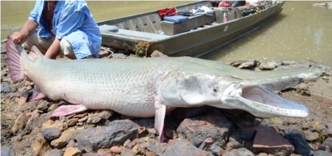
We saw more garfish in the New Madrid bend than we had seen to date... some of them were big fellows, rolling their big scaly bodies full length on the surface. Gar have stiff bodies. They are primitive fish with undeveloped vertebrae. Their rough hide, toothy jaws, and dead-looking eyes present a far from handsome appearance. Look at a garfish and prehistoric gates seem to open. We never had one on the end of some tackle but heard that they can be terrific fighters.
New Madrid is another town frequently mentioned by Mark Twain. The channel must not have changed much since he wrote about the town. It still sprawls out, close to the river in the lee of a fairly high levee. None of the landings looked too good — there was a sort of gummy looking clay along the shore at that point. This is one of the worst parts in landing a kayak. The guy who steps out first (me) is always a sort of guinea pig. Sometimes the footing is sound but there are times when the experimenter is going to get a good mud daubing if he isn't careful. Jackson and I argued at some length about a mooring place... meantime the current was carrying us past the town. Howie pointed out a little promontory which, he swore, was a good safe spot on which to tread. We nosed in; I stepped — and the mud did the rest. Up to my knees again. Immediately I established an "I told you so" attitude and some mighty harsh words were spoken. We walked into New Madrid in silence, had our lunch in silence and didn't break it until that evening when we hit mile 883.
Made good time the next day. The land continued flat — the continuous belt of cottonwood and willow trees just as even as a trimmed hedge, still met our eyes. The water situation was bad. Signs of habitation were scarce and a quart of water a day is hard to stick to when the sun gets hot. We were forced to walk inland for large distances to get water.
Got in to Caruthersville, Mo at about four in the afternoon and spent nearly all the rest of our dwindling bank roll on groceries. We had more than a hundred miles to go to Memphis. Howie had made arrangements with his Uncle Jim Oattis there. We had also forwarded money to Memphis — a precautionary measure for which we were thankful.
We camped the night on a sandbar south of Caruthersville. It was a fine site. The sand was white and clean — there was lots of driftwood. Another clear night went by. We left early the next morning, determined to make good time... it was either do that or go hungry for a few days. We had less than three days supplies.
After Caruthersville the trip really begins to get lonely. There are miles and miles of deserted shoreline... even a small fisherman's shack is an oddity. The timber grows right up to the banks, apparently unaffected by the high water in the spring.
Howie and I made our lunch stop at Osceola, Arkansas — we thought for awhile that we had missed our destination as a channel leading to the Osceola chute marked on the map was no longer navigable. We blew the rest of our swag on hamburgers and cokes. Memphis seemed a long way off to go on empty stomachs. Well, one good thing — there were plenty of good dry sandbars to camp on.
We had a chance to see what the river could do in a short time. There was one chute (channel) going in to Osceola. It looked good on the map but no longer existed on the ground. Instead a new channel had been made by the river in the meantime. We were afraid for a while that we would miss Osceola completely as the new channel was a couple of miles down from the old one. When we did find it, it meant going against current to get to the landing. The landing consisted of a number of large logs tied together. There was a small kid on it who warned us to watch ourselves around the dock. It seemed that he had just finished killing three cottonmouth moccasins which were living about the landing.
After spending the rest of our money at Osceola we explored the town at our leisure. It's a sleepy southern town... the poorer section just back of the levee. Many old buildings... not much commerce.
After getting started that afternoon, we had a break. A river boatman slipped us a chunk of ice which tasted better than candy in that hot weather. Some of it we broke up and put in our canteens. 57 miles to Memphis. Late in the evening we passed a section of high bluffs on the Tennessee side. An old fellow pulled up to us and gave us a hail. When he found out where we were from he cheerfully told us that there were quite a crew of us Yankees who had been pushed off that same bluff back during the Civil war. According to him there are still some Union cannon rusting on the bottom. The Rebs had a real victory... they completely encircled this Union force... then blasted them off the bluffs. The spot is right across from Morgan Point mile 772.
We spent the night about 3 miles below this spot. Earlier in the evening we crossed the deepest point in the river... 120 feet... this is across from Richardsons landing. Just as we got there we noticed that a large crowd had gathered on the Tennessee side. It seemed that a man had left his jeep parked right on the edge of the bank... in it were his wife and young son. The wife started the car (which had been parked in reverse) and it backed off into the river. The woman got out all right but they were still dragging for the boy. The river had claimed another victim.
We spent the night on the deck of a ferry boat, whose captain gave us a cordial reception. The next morning he blew us to a free meal and some of the strongest coffee I've ever tasted. Had to check the spoon after stirring to make sure it hadn't corroded away.
Arrival at Memphis
We really hit the paddles — going from Richardsons landing to Memphis by 2 P.M. An engineer boat gave us a hail, telling us of Howies mothers illness and we wasted no time in pulling in to Memphis... locating Howies Uncle and getting Jackson home. He left on the morning of the 24th with his uncle and fortunately all was well after he got there... had us all worried.
Having gone as far as Memphis I have decided to finish the trip. Have placed an ad in the paper (Commercial Appeal of Memphis) hoping to find a fellow traveller. Found a willing citizen by the name of Jim Eldred of Louisiana to whom the trip would seem a lark.
The weather below Richardsons landing toward Memphis was the hottest yet. We were hungry and hot but making good time. What really speeded us up was some news which a passing Engineer stern wheeler gave to us. They had been looking for us all up and down the river. Jacksons mother was ill and asking for him... according to the pilot she was on her death bed. You can imagine the effect this news had on Howie. We went as fast as possible... to the point of complete exhaustion. Took one stop only and it was a short one... went in for a dip to cool off.
It was a clear day 1... the 23d and we could see the buildings of Memphis from far away. We cut up the Wolf River (black as tar and malodorous) and pulled the kayak up on the docks of the Memphis Yacht Club. We then hustled up the revetment to the main part of the city where Howie put in a call to his uncle Jim who drove down to get us.
Howie left the next morning while I was still asleep. He seemed in accord with my idea of finishing the trip and felt badly about not being able to do it himself.
Spent the rest of my time in Memphis at the Oattis residence. Put my ad in the paper and while waiting for an answer I took a better look at Memphis. It is the cotton capital, a large and very neat town. Went out to the Southwestern University campus. Visited the Sigma Nu chapter there — the president at the time was Billy Hightower, who certainly was a fine person. Those of the chapter who were present treated me cordially. Also stopped in at the biology department and had a long talk with one of the botany professors who showed me through the herbarium. He also clewed me in on much of the local flora.
The day after Eldred answered my ad, we set out for points south. Jim was an ex-Navy man and though that he could have been a two-fold trip... His home was in Louisiana and he liked the water. His enthusiasm was dampened a little when he saw the size of the craft and a little more when, one hour out of Memphis, we had to stop to make repairs. We had had the kayak up high and dry for four days and the stretching of the canvas had put a couple of holes in it. We probably worked too hard that day... it was as hot as usual and I was more used to paddling than he. I had the position at the rear of the kayak as steersman.